Geospatial needs to be defined

If you know, you know. That is a very short way of saying that “geospatial” lacks definition.
In the past few years, and more so recently, I have seen more and more people who state that they work “in geospatial” or are “doing geospatial”, alongside a rise in many different job titles that have the word geospatial or spatial in them. Traditionally, the term geospatial was reserved for data or a larger community of users, but certainly, it had expanded well beyond that now.
It’s clear that there is a geospatial industry, geospatial community, and growth prospects for the industry. Yet if you search online there is no clear definition of geospatial, or even many attempts to put structure around what geospatial is.
In addition, there are only a handful of degree programs dedicated to geospatial. And to say that I think you must have a university degree to work in geospatial is far from the truth (I am a big believer in ongoing and non-traditional education) but it provides a barometer into how the world views geospatial as a practice area.
With that said, I think it is important to define what geospatial is, not for the sole sake of placing structure around it but to help guide what geospatial should accomplish, how it is practiced, and how we can avoid some pitfalls from how GIS was defined and practiced.
Why hasn’t geospatial been defined?
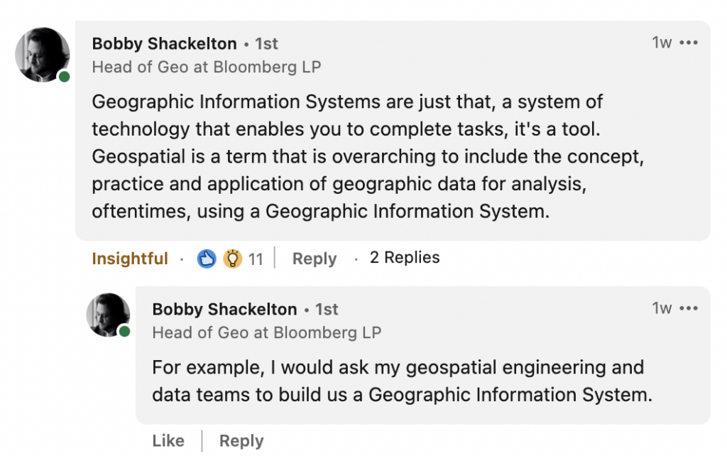
Before going into detail on this topic, geospatial itself is a much larger area of focus including the data, technology, concepts, development, application, and practice to analyze geospatial data. This was best summarized by Bobby Shackelton, Head of Geo at Bloomberg:
This post will focus on geospatial as a practice area, which in my opinion, is the fastest-changing part of geospatial but also the part that has the least definition.
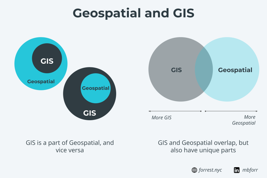
Overall, it is hard to define if geospatial is a part of GIS, GIS is a part of geospatial, or they are in a symbiotic relationship. The answer could be all three (personally, I think GIS is one part of geospatial, but geospatial as a practice is becoming more defined) but it is likely this debate will continue in the future.
GIS is more established
A lot of the reason why has to do with GIS. Geospatial and GIS will always be intertwined in one way or another, where GIS is the more established of the two siblings, and geospatial is still going through some growing pains. Both are important and powerful in their own right, yet still unique and different.
GIS already exists and has a clear support structure from secondary education, ongoing education, events, commercial software, and a roughly 60-year history counting from Roger Tomlinson’s work in the Canadian government in the 1960s.
Geospatial certainly has some of this infrastructure – a great community, events, global reach, and technology – but GIS has both the history and other infrastructure set up to support it.
Since both are quite similar in a high-level sense of what an end-user might interact with (generally speaking, maps) it might be hard for that user to distinguish a product or tool developed with GIS compared to geospatial.
Of course, those working in either field likely know the difference, but imagine for a moment you have two web maps – one built using GIS and one built with open source tools with lots more data. Someone who doesn’t work in GIS/geospatial might say “they both look like maps, can you explain the difference”. The simple fact that the difference has to be explained shows how closely related GIS and geospatial are, despite their differences behind the scenes.
Sign up for my once a month newsletter about all things geospatial
[mailerlite_form form_id=2]Strong ties to the public sector
GIS has long been closely tied to the public sector, and for good reason. The public sector is responsible for generating massive amounts of critical GIS data that keep operations like emergency services, utilities, roads and transportation, buildings and permitting, and everything in between. All this data depends on GIS technicians in the public sector, and we consume lots of this data in geospatial workflows too.
With such critical data depending on GIS workflows and tools, taking on a new workflow or open-source tools can be a challenging proposition for a public agency. Not to say that it can’t be done (the NYC Department of Planning Zoning & Land Use Map is a great example) but that it needs to be well thought out and executed, and the transition can take years to ensure continuity between workflows without the right support.
There is an imperative for this to change, however. Just as other organizations are seeing data sizes and volumes increase, so too is the public sector.
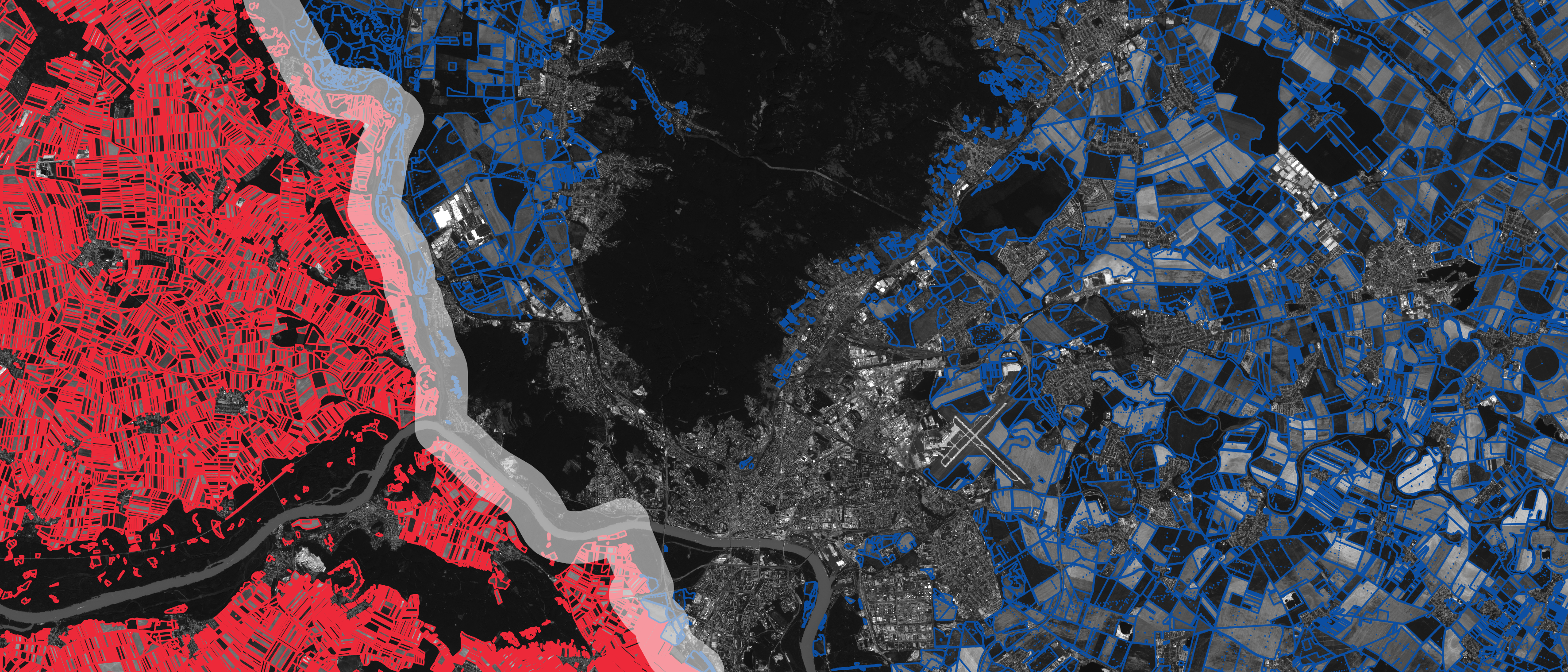
Even 5 years ago, it might be hard to imagine that the City of Chicago would be hosting a 197M row (and growing) dataset of taxi trips on its open data portal. Yet today, you can find it and many other large datasets being produced by public agencies.
The technology and practices needed to support this scale of data is a prime use case for geospatial, as GIS has some limitations in the scale of data it can work with as many of the tools used in GIS are desktop-based and don’t use scalable cloud technology. Beyond the data, creating tools and solutions for the public to interact with this data provides an even more pressing need for geospatial solutions.
Higher education is less focused on geospatial
GIS education is an integral part of almost any geography program at the university level and has been for years. Many schools offer multiple levels and types of GIS degrees, and while students will likely touch and use tools commonly utilized in geospatial workflows, the degree programs still focus on GIS.
There is a good reason for this as there are many GIS careers and clear career paths for those with GIS degrees that need to be filled to work on critical data and projects. However, this sets up a few other issues when it relates to geospatial.
First, geospatial lacks the clear blueprint of learning paths that GIS has. Geospatial has the advantage of generally having a lower barrier to entry since many tools are free and open-source, but the burden to learn them is still on the student many times. If you go down the traditional GIS path, you have that clear blueprint and may learn some of those geospatial tools, but you will still have to do some self-learning after the fact. Speaking from experience, I took the later path, and while it’s doable, there is a lot of trial and error involved.
Next, is the recognition and validation that comes with completing a degree program. While I believe that continued education and non-traditional education like online courses and books are valid and valuable methods of learning, the fact that one can complete a GIS degree/certificate/masters/etc. does carry some weight. And the fact the same standards and certifications don’t exist, either in traditional or non-traditional education methods, for geospatial I believe is detrimental for the advancement of geospatial as a practice.
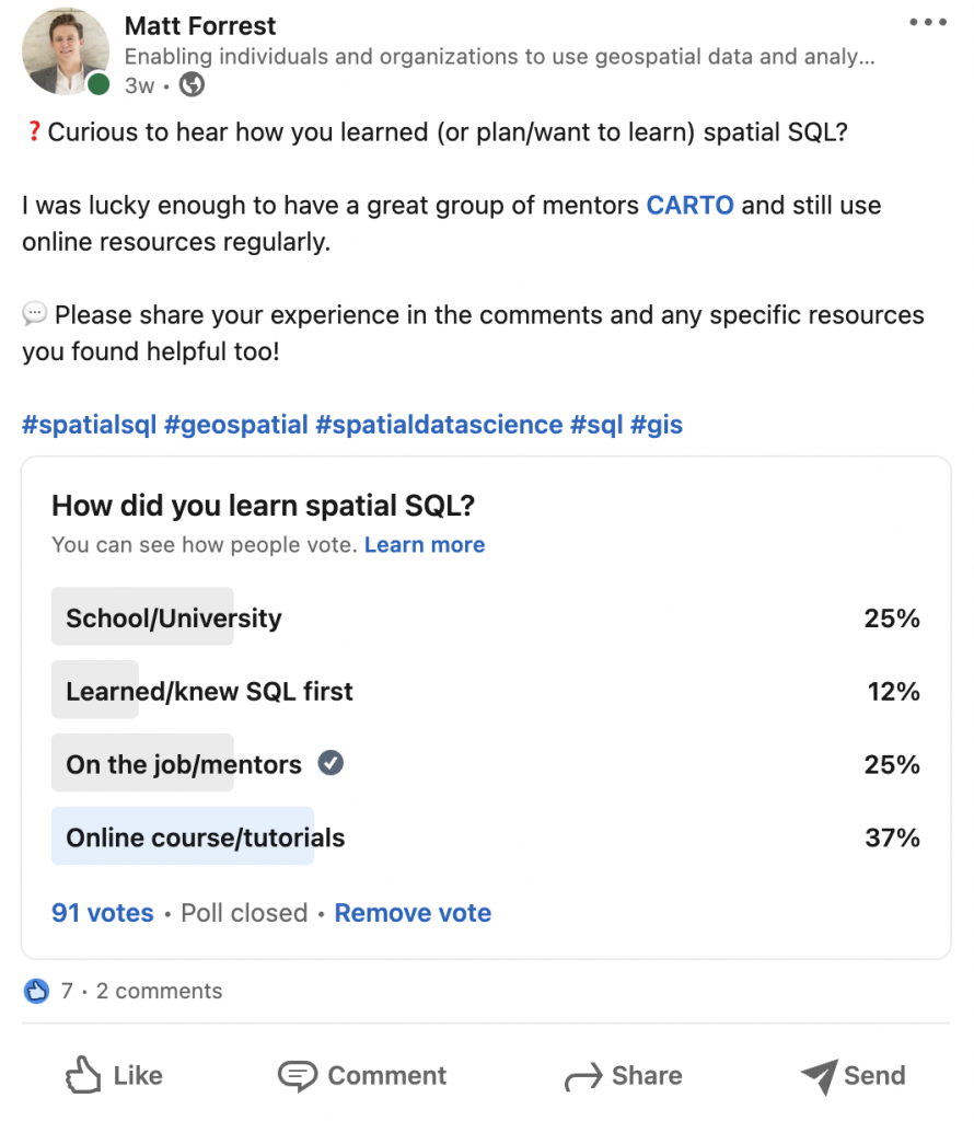
I get asked all the time what are the tools and skills needed for someone who wants to get into or make the pivot to geospatial. There are lots of great resources for learning specific skills like spatial SQL, Python, spatial data science, etc. But there are so many other things that are picked up along the way that are just as important:
- General data science and machine learning
- Database design and management
- Application architecture
- Cartographic visualization
- Interacting with non-geospatial teams
All these skills, including those generally categorized as soft skills, are ones you have to learn on your own for the most part and can’t be found in geospatial tutorials and courses.
Being able to have the certifications to say what you have learned, knowing what else you need to learn, and the paths to use those skills are important to continue to grow geospatial.
Career paths have only recently started to open up
Just as there are clear and defined education tracks for GIS, there are also a wide variety of clear and defined career paths for GIS. Geospatial, on the other hand, has not had the same set of clear career paths as GIS.
The traditional path for someone leaving with a degree or skills in GIS is to and enter a career as a GIS analyst in either the public or private sector. There are also clear paths for advancement within these roles and ongoing certification and career advancement.
Geospatial has not had the same direct career path as GIS, at least not until recently. In the past, someone working in geospatial may have found themselves in any number of roles: product manager, developer, any number of GIS roles, database admin, analyst, developer, business intelligence, data science, or a range of specific business unit lines (such as retail analytics for geospatial use cases).
On top of that, each of these roles has its own set of career paths and progressions that may or may not include geospatial skills.
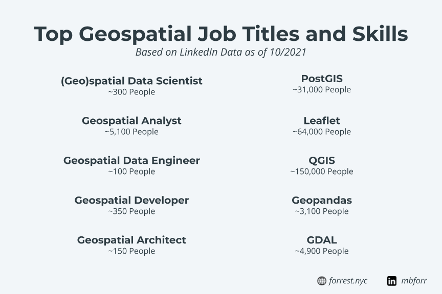
It wasn’t until the last few years where more roles started to show up with a specific geospatial focus and skill set, consistent across roles and organizations. Positions such as Spatial Data Scientist, Geospatial Architect, Geospatial Data Engineer, Geospatial Analyst, and more are great examples of this.
I hope this continues to grow and expand, and that the career progression and paths can grow along with it, as well as specific teams focused on geospatial can form within larger organizations, rather than geospatial roles being absorbed into other teams.
Geospatial is a distinct practice area
Geospatial has always been a distinct market, estimated to almost double in size from $59.5B to $107.8B between 2021 and 2026. However, it has not always stood out as its own practice area (meaning with common practices, distinct areas of knowledge, processes, and paths for advancement) the same way it is in GIS.

Geospatial today tends to focus more on technology and data, and a robust and vibrant community of users of those tools/data. It feels much earlier in its life compared to GIS which is already well into its adult years.
In fact, there are only a few attempts to define what geospatial is currently. Most current definitions of geospatial tend to focus on data – what it is, how you can use it, and the value you can derive. I was able to find two definitions of geospatial that look at beyond just data:
The first is from GIS Lounge:
The term geospatial is a term that has only recently been gaining in popularity and is used to define the collective data and associated technology has a geographic or locational component.
The second is a great article by Will Cadell from Sparkgeo
Geospatial turns GIS into code. That only happens if the process is necessary to repeat many, many times, as is the case for consumer web applications. But in the end, geospatial people take a GIS workflow and scale it.
Yes, I know, we have had people writing code in GIS for years and years. But only recently has the consumer sector been interacting with that code.
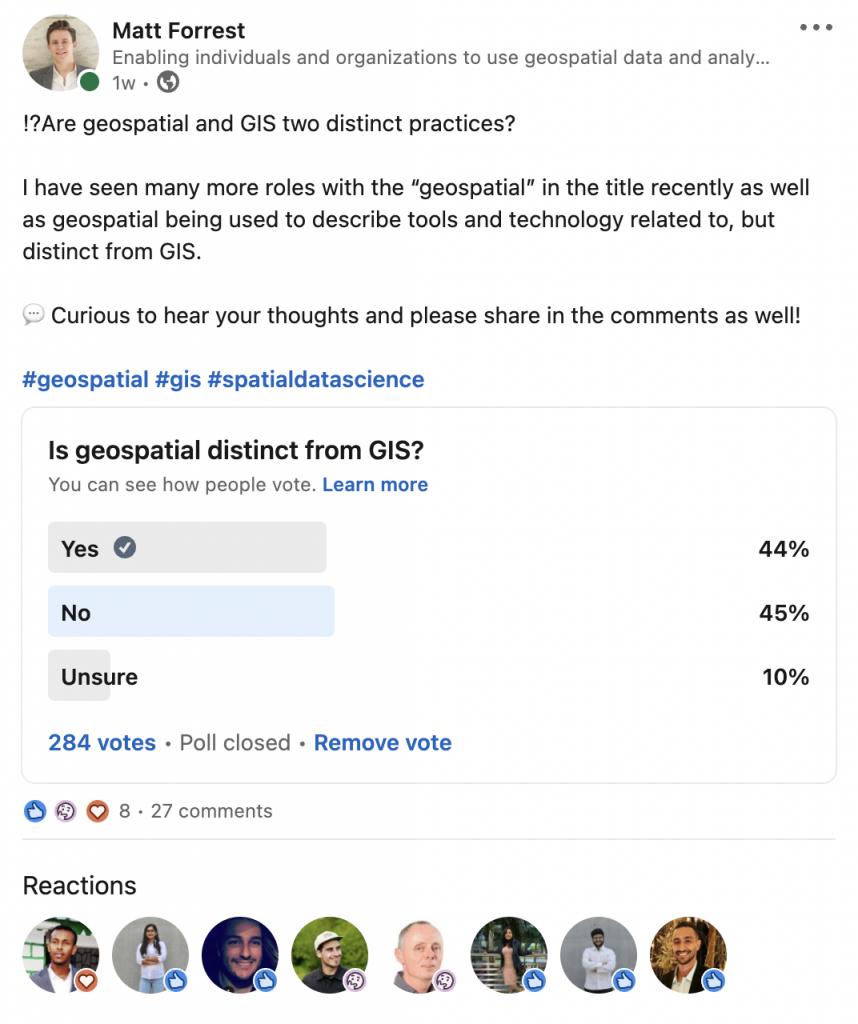
I recently ran a poll on LinkedIn asking if GIS and geospatial were two different practice areas, and the results were pretty evenly split, but there were some great answers showing how you can define the two areas as well:
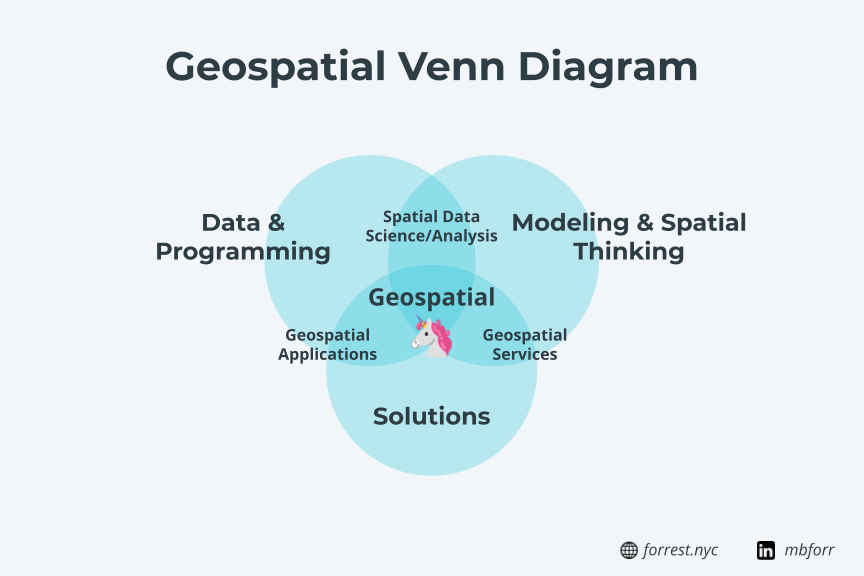
Clearly, geospatial is not just the data, but the technology and the practice of implementing that technology for end-users. In my opinion, there are a few key things that make geospatial stand apart as a unique practice area:
Data, both complexity and scale
People tend to move into geospatial or use geospatial tools from GIS or other areas for one key reason: the data they are working with is either too big or complex to fit into a traditional GIS workflow or the insights they need to produce need higher flexibility than their current software can provide.
This is the first key point about geospatial – the tools and techniques utilized in a geospatial practice allow for users to analyze, query, process, transform, and manage large scale and complex data. I define large scale as either the number of rows, columns, complexity (geometry or types of data), and variety (number of file types for example).
Technical toolkit
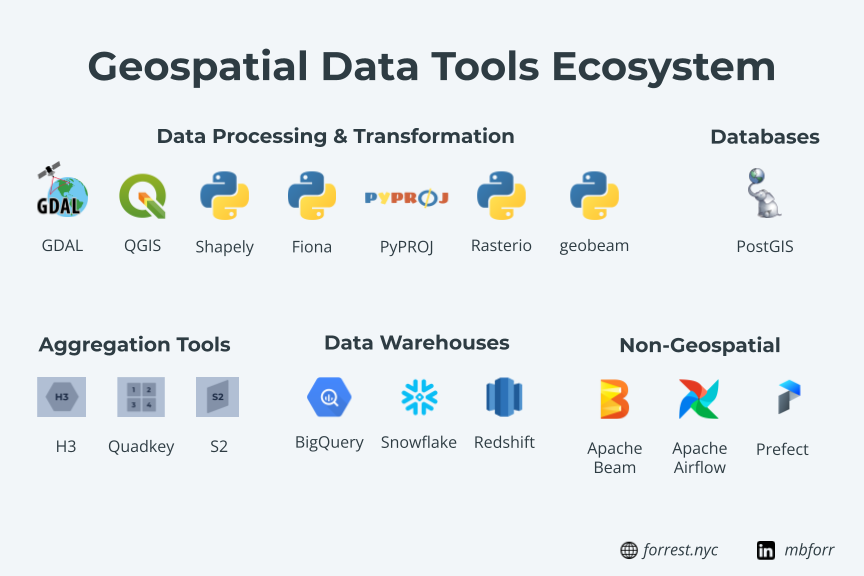
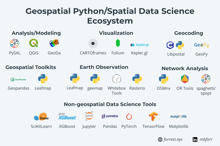
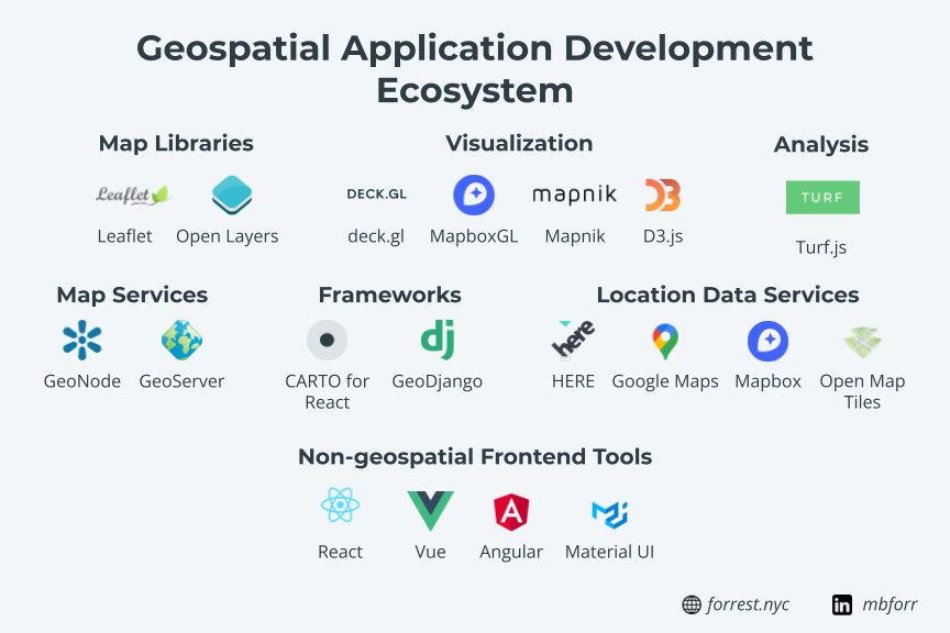
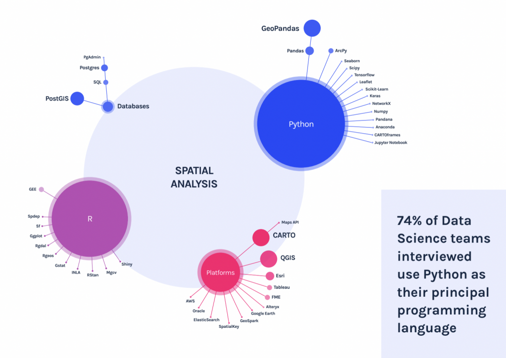
Geospatial overwhelmingly tends to be a more technical toolkit compared to GIS. While you are likely to find plenty of GIS analysts and practitioners that use Python, SQL, Javascript, and more in their workflows, the geospatial space tends to be code first whereas GIS tends to be tools first, code if needed.
Flexibility
The other reason I have seen people move from GIS or other workflows to geospatial is flexibility. Traditional GIS desktop workflows are great but if you need analysis or outputs that go beyond what that can deliver, geospatial provides any number of options for you to do so.
Analytics and data science
The growth in analytics and data science in the past few years has exposed many more people to geospatial analysis in BI tools and spatial data science. This means that there are lots of people using geospatial tools and, in effect, practicing geospatial. This is a great development but calls for the need for standard practices even more.
Integration and collaboration
Since many geospatial tools are open source, use common languages or software, or are extensions to other common tools/services means that geospatial is a more integrated practice at a core technology level.
For example, if your organization already uses a PostgreSQL database, you can easily use spatial capabilities with PostGIS in that same environment. The same goes for many other geospatial workflows.
But beyond that, geospatial users tend to collaborate more or are directly integrated into other business units. This differed from GIS where there tends to be a GIS team that has its own tools and processes, and does not directly integrate the same way.
Solutions and scalability
The final component that I believe differentiates geospatial from GIS is in the outputs or deliverables that geospatial can produce. Our earlier steps allow us to use larger-scale data with more flexible analytics because of flexible and scalable technology.
The same happens to be true on the final outputs of geospatial. Users can deliver everything from:
- Simple dashboards
- APIs
- Reports and maps
- Datasets
- Lightweight applications
- Full-stack applications
- Integrations to other systems
- And more
The fact that geospatial libraries, both backend and frontend, allow developers both geospatial and otherwise to use development best practices and other open-source projects to focus on the work of delivering solutions.
In addition to the flexibility in the types of solutions that geospatial can deliver, they can be developed in such a way to match the appropriate experience (how they want to achieve it) and desired outcomes (what the user wants to achieve) for the audience consuming them. This is actually a concept from Lincoln Murphy, a customer success expert, but it speaks to the ability to develop solutions specific to any audience.
GIS traditionally forces you to outputs in formats that they have available: data viewer, web maps, story maps, etc. Geospatial does not have these limitations due to the technical flexibility and ability to integrate with other libraries and systems.
For example, if you have a real estate developer that wants quick statistics about an area or listing, certainly both GIS and geospatial can help them find that data. However, GIS may not provide a tool that matches the appropriate experience for that agent, as they need a web app on their phone where they can enter an address and get back data in seconds. Geospatial has the flexibility to do just this, and more
How geospatial differs from GIS and why this matters
There are some important differences between GIS and geospatial that are important to note:
GIS can be an island
Within many organizations, GIS teams tend to be isolated units that receive requests from other teams and then deliver results and outputs back. Sometimes they are integrated into other groups, but you will likely hear the term “GIS Team” when talking about a GIS group.
Geospatial can follow this same pattern, but more often you will find users practicing geospatial within other teams – both technical and business units.
It’s harder to let others participate
GIS tools can tend to be an insular set of tools and technologies, and it can make it difficult for others using different tools and technologies to collaborate and work with those tools and workflows. A simple example is connecting to live or updated data from a GIS server to a BI tool or external app.
Geospatial on the other hand is built as a part of or using programming best practices, and in turn, can integrate with existing toolkits other teams are already using. PostGIS is a part of PostgreSQL, Geopandas is linked to Pandas, etc.
Education can be a barrier to entry
Finally, education can be a barrier to entry as GIS is generally taught at the higher education level, although online courses and certifications have started to expand in recent years. Nonetheless, GIS software generally has a high learning curve for new users, technical or non-technical.
Geospatial technology allows someone who may have skills in an existing language or toolkit to pick it up and start using it UI joy with their existing knowledge.
What geospatial doesn’t lack
Before we dive into the elements that geospatial needs to expand into a defined and unique practice, I think it’s worthwhile to look at the amazing things that already exist in geospatial today.
A vibrant community
The geospatial community as it exists today is one that is extremely engaged, wide-reaching, passionate, welcoming, connected, and participatory.
In just about any corner of the internet, you can find people who are or using geospatial tools and data carrying on conversations, sharing knowledge, and engaging with each other.
There are plenty of places where these conversations happen, both on social media, podcasts, newsletters, events, blogs, and otherwise, and it’s easy to jump in and start engaging right away.
Technology
Geospatial technology is flourishing and there are constantly new tools and components being created and modified across all areas of the space. Comparing the ecosystem today to what it was even a few years ago, the speed of development and choices is impressive. This is one area where geospatial is thriving and continues to thrive as even more options are being developed all the time.
Experienced users
There are a large number of users of these technologies as well that have both depth and breadth of experience using them for product development, open-source applications, data management, data analysis, and more. These experienced users show not only that geospatial has a strong base and historical precedent, but also a large group of leaders and experienced users that are already making impacts in their own organizations.
Global reach
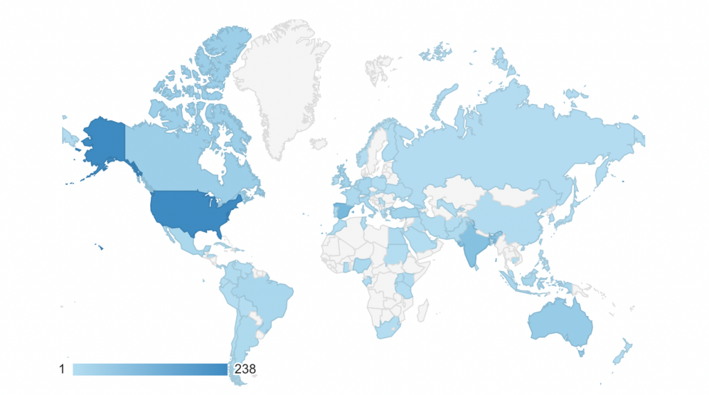
Geospatial is global. One thing I have learned is that there are people using geospatial technology in just about every place around the world. I certainly knew this, but I am constantly blown away by the different communities that are practicing geospatial around the globe. Just the modest number of visitors to this site shows the reach of locations where people are coming from, and now there are even regional geospatial podcasts starting to show up as well.
Geospatial needs five things to define itself as a practice
Compared to GIS and other technical practice areas, there are five main areas that can help geospatial become a more defined practice. Before that, I do believe it is worth offering my definition of geospatial as a practice:
Geospatial is the practice of using technology to analyze geospatial data to deliver actionable and relevant insights
To break this down a bit:
- Geospatial is the practice… – yes geospatial is a larger term used to define data, technology, users, and community, but in this definition we are focused on the practice and execution of geospatial
- …of using technology… – this could be any combination of technologies, but geospatial makes use of technical toolkits to deliver insights
- …to analyze geospatial data… – the goal of the geospatial practice is to analyze and understand geospatial data of all types
- …to deliver actionable and relevant insights – geospatial has many different types of outputs, but all focus on delivering actionable insights to users in a relevant format to the user
I believe these elements broadly capture what geospatial is today, however defining geospatial is one step among many that need to be worked on to make that more of a reality.
Define geospatial as a practice
First, the geospatial practice needs to be defined, not by one person, but by the community of users, developers, analysts, and end-users of geospatial solutions and technology. More than likely there will be several varying definitions, and given the pace that geospatial is changing, this definition may shift and change over time. I do believe that to properly define it as a practice the definition should contain a few key elements:
- How are geospatial workflows performed (i.e. are they technical in nature and what types of technology)?
- Who uses geospatial tools and technology and who consumes the outputs from them?
- What are the outputs of geospatial and what do they look like for end users?
- How are geospatial projects defined, scoped, and developed?
- How do geospatial teams interact with other teams, or are they integrated in
- What do the teams that practice geospatial look like?
- How can you learn and develop skills in geospatial, what are geospatial career paths?
- What are the problems/use cases that geospatial can be used for?
This will require more than just a one-line definition, and the input of the people actually using and practicing geospatial will be critical to help structure what the practice of geospatial actually looks like.
Provide academic options and certifications
While I do believe that traditional degree and certificate paths from institutions of higher learning will be key to defining the geospatial practice, I believe this goes far beyond just that. Defining academic options for learning geospatial requires three key components:
- The required learning topics or course work that goes into mastering geospatial
- The different learning paths that you can take while practicing geospatial
- The places where this learning will take place and what each can offer
Defining what would traditionally be defined as coursework for a geospatial program is the first step. There are many different options of what this can look like but a small selection of ideas might be:
- Managing and Transforming Geospatial Data
- Application Development
- Spatial Data Science Modeling Techniques
- Spatial SQL for Analysis
- Spatial Database Design and Structure
- Geospatial Services and Architecture
- Designing Geospatial Solutions with Internal Stakeholders
- Geospatial Product Management
I believe that designing functional topics for both technical and soft skills allows geospatial to help structure what the geospatial practice actually comprises, but also allows for certifications and degrees to show the validation that an individual has completed those topics.
This leads to the second point, which is defining learning paths. Just as there are different career types in GIS, so too are there in geospatial. Defining the respective topics or coursework that specific roles would require would help define the required skills for these roles, but also ensure that there are opportunities for career path development or changes within the space. For example, a learning path for a Geospatial Data Engineer will look different from a Geospatial Solutions Architect.
Finally, the places these topics and learning paths can be learned is another key component. I believe that traditional higher education will and should be a part of this, but so too should other learning methods such as online courses and certification. I believe that many people learn their technical geospatial skills online and in other settings than a traditional classroom, and this should continue as it enables many more people to learn geospatial.
Develop and define career paths
Building upon the need for learning paths, there should also be clearly defined careers and career paths for geospatial. There are already many different career types in geospatial, and the space is continuing to grow, but some of these lack definition, and the different tools and stacks can look different between each organization.
Geospatial Data Engineer is a recent role that I have seen growth in recent years, yet there is no defined learning path to learning the skills to be a Geospatial Data Engineer (I would imagine that many people in these roles come from a variety of backgrounds and skillsets), and the skills can vary between job postings. Having the ability to not only have a clear path to learn these skills, the support to learn them, and the path and job pool to go into these roles is the ideal goal for defining the functional roles for geospatial.
This also allows us to break up the work of geospatial into different areas of focus, and not have the need for geospatial “unicorns”, or those people who do it all in all different areas. You can dive deep in one area, work and collaborate with others, learn and advance your career path, or possibly pivot and switch career paths will only help to develop and grow geospatial.
Integrate geospatial into organizations
Geospatial is already being practiced in different teams in various forms as discussed earlier, but finding ways to both integrate individuals into internal teams and creating cross-functional geospatial teams allow for both technical collaboration and delivery of high-value solutions.
This is one area where GIS being an island has hurt its ability to provide impact within organizations. Geospatial practitioners are generally integrated into other teams and are working on geospatial problems within business units. In many cases, these are technical groups like data science, business intelligence, or advanced analytics teams.
Where I think geospatial can add even more value is when geospatial teams can work alongside business unit teams to solve specific problems – almost like a geospatial SWAT team that can be deployed to embed within other teams to help them build solutions and solve problems, allowing them to truly understand how those teams work and the insights that they need. For example, a geospatial team with a mix of roles can embed with a marketing and consumer insights team to help them develop a solution to understand customer segmentation and geo-marketing insights.
This is the advantage of geospatial, is that not only can these teams build customized tools and solutions based on the teams’ needs, but they can embed and work alongside non-geospatial teams and integrate from a technical perspective since the geospatial toolkits already integrate with existing tools.
Define possible outcomes and outputs
Finally, since geospatial can deliver so many different types of outputs to stakeholders, and while it is great that these results can be anything for any audience, having some definition around the types of deliverables, their advantages and disadvantages, who they make sense for, and what use cases/problems they can solve will help those working in geospatial align the right deliverables to each audience. Some examples of deliverables from geospatial could be:
- Dashboards
- Data
- Reports
- Microservices/APIs
- Small applications
- Full-stack applications
- Data Science Notebooks
- Scripts and workflows
- Maps and visualizations
Enabling geospatial teams to know which deliverables and outputs will serve specific use cases, and the best practices around delivering each will help bring greater value and cross-collaboration within the geospatial practice.
Why creating this space matters
There are a lot of reasons for ensuring that the practice of geospatial is defined. Not only will it help validate the work that many are already doing in the field, but it can improve collaboration and help solve some of the most pressing problems in our communities, businesses, governments, and organizations.
- Improve collaboration between geospatial, non-geospatial, and GIS teams to ensure ideas, best practices, and skills are shared between groups that may not otherwise communicate and work together
- Enable more people to use geospatial technology and data, and think spatially through awareness, ability to learn, and ability to use those tools in the real world
- Build more effective solutions and share best practices for deploying geospatial solutions in organizations and ensuring common best practices for building and scoping solutions
- Work on some of the most complex geospatial-centric problems in our world today such as climate change/resiliency, supply chain/logistics, equity/fair access, transportation planning, population change modeling, food and water access, healthcare planning and access, telco and utilities planning, energy monitoring and planning, and more.
What’s next?
This post is meant to offer my ideas and opinions about how to form geospatial as a practice, but I am one person. It will require the input and application of those working with geospatial technology and others to help bring this to life.
- Create a conversation around what a geospatial practice looks like among the geospatial communities
- Create a consensus within the geospatial community around definitions and structures for geospatial as a practice
- Define the tools and skills needed to practice geospatial
- Begin to define different career paths
- Define and develop education programs, courses, online resources, certifications, and degree paths for geospatial
These are my ideas and thoughts, and real progress will be made by debating and discussing these ideas in the geospatial community, so I invite you to continue this conversation in various channels and locations to help continue to define what this looks like.