
🛰️ Introducing “Signals from the Surface” & Valencia Flooding
A few months ago I got a message from the person I will shortly introduce on LinkedIn. The idea was simple (and one that I had been interested in working on) – partner up to share more resources to the geospatial community on the overlap between geospatial and earth observation.
Now for me EO is my weak spot. I know how to work with raster data (read prepared raster data) but many other aspects of it (time series, deep learning, foundational models, etc.) are things that I am still a novice in.
Mina Nada will be helping me in this venture and I am excited to get the chance to work with him. But I’ll let him introduce himself here:

Mina is an applied geographer and geospatial data scientist dedicated to driving impactful solutions to advance environmental conservation. With experience spanning roles at ICEYE, NASA, and the National Park Service, Mina specializes in GIS and remote sensing to tackle complex environmental and societal problems.
Passionate about open data, sustainable agriculture, and fostering resilient cities, Mina uses his expertise to illuminate connections between landscapes and the global food system. You can explore his work on LinkedIn or dive into their creative projects: The Atlas Botanica on Instagram and YouTube, where they inspire deeper connections to local landscapes through gardening and workshops, and Source of Flavor (sourceofflavor.com), a platform uncovering the journey of food through the lens of remote sensing.”
And with that here is the first “Signals from the Surface” – this time focusing on the recent catastrophic flooding in Valencia, Spain. Mina has taken the lead here but I have added some of my thoughts which are called out in the text.
In October 2024, a catastrophic weather system known as a DANA (isolated high-altitude low-pressure system) unleashed torrential rainfall on Valencia, Spain. Within hours, regions such as Chiva received up to 500 millimeters of rain, resulting in flash floods that devastated urban and agricultural areas alike. The floods claimed over 200 lives and left hundreds more missing, while submerging over 33,700 hectares of farmland.
A Critical Hit to Agriculture and Food Security
Valencia’s agricultural sector, a vital contributor to Europe’s fresh produce supply chain, bore the brunt of this disaster. Initial estimates by the Valencian Farmers’ Association (AVA-ASAJA) placed agricultural damages at €1.09 billion, encompassing crop losses, infrastructure destruction, and soil degradation. Citrus crops, accounting for €192 million in damages, were particularly affected, followed by persimmons (€54 million), vegetables (€25 million), and avocados (€7.2 million).
Compounding the crisis, many trees in orchards were submerged for over 36 hours, leading to root asphyxia and heightened vulnerability to fungal diseases. Additionally, essential infrastructure—such as irrigation systems, rural roads, and packing facilities—sustained damage amounting to €486 million.
The floods’ impact extended beyond Valencia’s borders. Spain, which supplies 25% of the United Kingdom’s fruit imports and 8% of its vegetables, is a cornerstone of European food security. Damage to citrus and vegetable crops could lead to shortages, higher grocery prices, and an increased reliance on imports from South Africa and Brazil.
This crisis underscores the fragility of global food systems in the face of climate-induced disasters. As extreme weather events become more frequent, the interconnected nature of food supply chains necessitates adaptive strategies and scalable technologies to mitigate cascading effects.
Local Solutions: Pinpointing Damage with High-Resolution Data
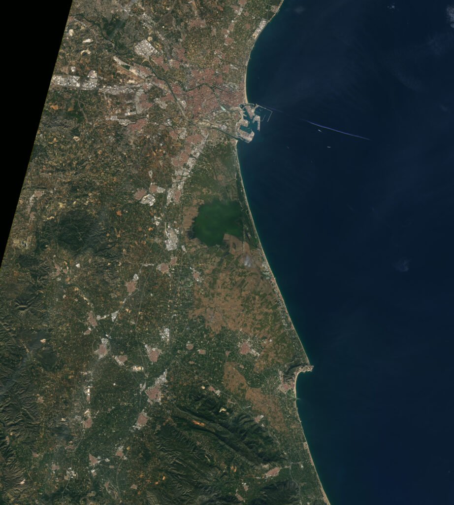
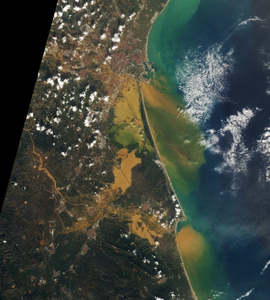
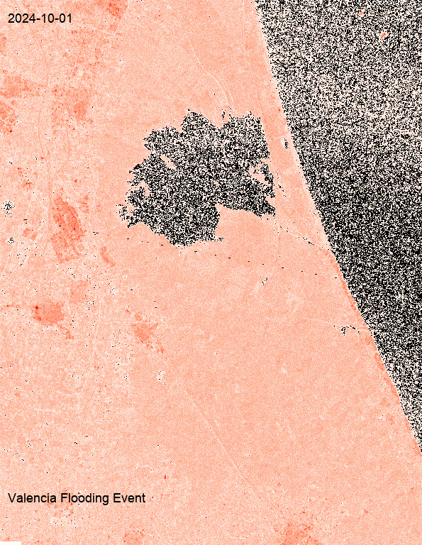
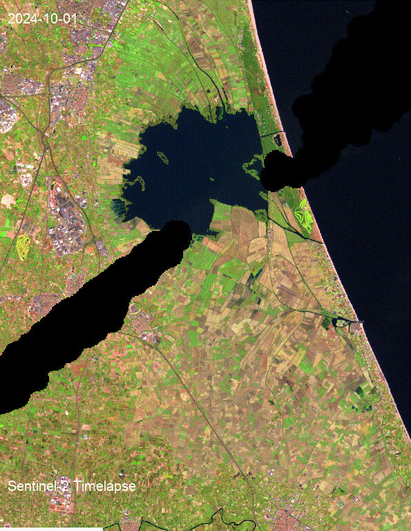
At the local level, detailed satellite imagery is invaluable for assessing flood impacts. Optical data from Sentinel-2, while effective under clear skies, was hindered by cloud cover during the Valencia floods. Radar data from Sentinel-1 filled this gap, enabling clear visualization of inundated areas. Using these datasets, animations have been created to illustrate the flood’s progression, aiding responders in assessing localized damage.
Furthermore, open-source tools like Overture Maps’ buildings dataset provide critical information on community infrastructure, helping emergency teams prioritize resources. This combination of high-resolution imagery and open data allows for granular analysis, such as mapping waterlogged fields or identifying affected rural roads.
Matt: When I think this underpins is the importance on radar-enabled Earth observation data to understand what’s happening and to clearly cut through cloud cover in certain areas. Synthetic aperture radar or SAR data is becoming increasingly important and having the skills to work with it will be important especially as more climate disasters continue to occur. This also highlights a key use case for Overture maps data. While there are many, having consistent building footprints available globally to easily identify different buildings and areas and densities of buildings makes this extremely valuable data set in these types of scenarios.
I’ll be honest, I haven’t worked a lot with SAR data, so I’m actually excited to understand this in more detail and maybe start to get my hands a little dirtier with this type of data.
Regional Solutions: Broad Insights Through Scalable Tools
On a larger scale, NASA’s Global Agriculture Monitoring (GLAM) system offers a country-level perspective on agricultural productivity. By aggregating data from multiple satellites, GLAM could estimate broader impacts of the floods, such as changes in citrus export volumes or disruptions to vegetable supply chains. These insights inform policymakers and international stakeholders, enabling more effective resource allocation.
Challenges in Scaling & Building Resilience Through Data
While local analyses prioritize precision, regional monitoring sacrifices detail for scalability. Bridging these approaches remains a challenge, but integrating both perspectives could enhance disaster response and resilience planning. For instance, local findings can validate regional models, improving their accuracy and applicability.
The Valencia floods serve as a stark reminder of the escalating risks posed by climate change. Scalable Earth observation technologies could play a pivotal role in mitigating these challenges, from monitoring immediate impacts to forecasting long-term trends.
However, the effectiveness of these tools depends on their accessibility and integration into disaster response frameworks.
Visual aids, such as the Sentinel animations and comparative Landsat imagery, not only highlight the extent of the flooding but also illustrate the potential of remote sensing technologies. By investing in both local and regional monitoring capabilities, stakeholders can strengthen food systems against future climate disruptions, ensuring a more sustainable and resilient agricultural future.
Matt: There are two points that I think Mina called out here that are really important. The first is that there is a need for understanding some of the ground truth data in nearly all scenarios. Models and data can only get us so far, but having some element of ground truth, be it from manual data collection or sensors on the ground is incredibly important. A good example of this is the US Water Model which has consistently updated data sensors on many United States rivers showing their height and flood state.
The other part is that it is great to have animations and information about this data after the fact. But I think more importantly is getting some sense of real time sensing when these incidents occur. This requires a different set of tools, ones that can scale, ones that can be run consistently and automatically in the cloud and can be used to get information into the right people’s hands very quickly. The modeling aspect is one important component, but the ability to scale this in a cloud environment is a different skill set that is also incredibly important in the modern geospatial world.
Sources
Damages to Valencia agriculture exceed €1B after floods
Devastating floods in Spain could have immediate effects on Europe’s food
Bitter harvest for Spanish farmers as floods swamp fields
Agricultural crisis: Valencia flooding decimates farmlands