

Put AI to work in your GIS and reclaim hours every week
Build a repeatable system for using AI tools like ChatGPT, Claude, and Cursor in your GIS and geospatial work, every day. Turn routine into leverage, become the person who ships high-impact work, and future-proof your career.
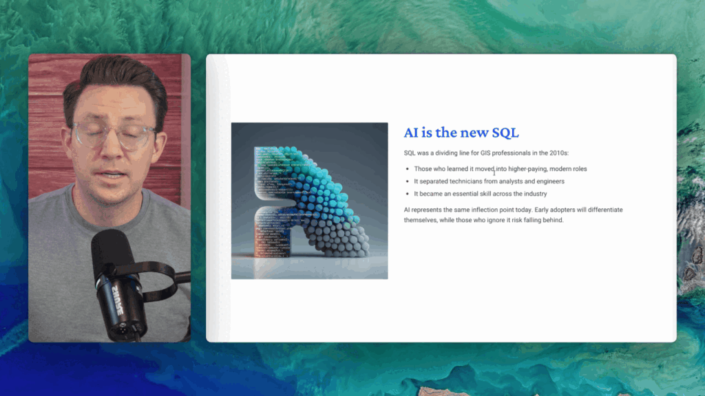
The people who systematize AI in daily workflows move faster and get picked first.
Adoption is here, training isn’t. 75% of knowledge workers already use gen-AI, but only 39% have company training—while 66% of leaders say they wouldn’t hire someone without AI skills. Microsoft
Measured productivity, not vibes. In a large field experiment, GPT-4 users completed 12% more tasks, 25% faster, with >40% higher quality; developers using Copilots finished tasks 55% faster. Harvard Business School, GitHub
Demand outpaces supply. Related geospatial sectors report rising skills gaps in AI/ML, and only 14% of GIS pros report recent vendor-neutral training—your edge if you can demonstrate cross-tool, AI-enabled workflows. GOV.UK
Bottom line: This course turns AI from a curiosity into a repeatable GIS workflow—so you ship faster, document better, and become the GIS super user your team relies on.
LEVEL UP
Why this matters now
GIS is changing. The professionals who learn to pair domain expertise with AI will out-deliver their peers, move faster on complex projects, and become the go-to problem solvers inside their orgs. If you can direct a copilot well, you do not just work faster, you work at a different level.
This course gives you the practical way in. No theory spiral, no vendor hype, just copy-ready prompts, workflows, and habits that compound.
Move 2 to 10x faster
on core tasks like cleaning data, fixing SQL or Python errors, and documenting work
Ship clearer analysis
with AI-assisted narratives, code, and strategic driven outcomes
Create repeatable workflows
that you can reuse across projects and teams with AI systems
Showcase portfolio-ready proof
that you can integrate AI into real GIS work
Stand out as a GIS super user
the person who brings clarity and momentum to messy spatial problems
Before the AI Copliot → After the Copliot


AI fixes code, explains errors, and suggests next steps
AI drafts map captions, methods, and clean project docs
You scope with structured prompts, then execute with confidence
You ride the wave of change, you are not dragged by it
How it works
What you will learn
This course moves you from quick wins to true leverage.
You will start by using AI to spark ideas and unblock daily work, then you will design reliable workflows that you can repeat, and finally you will build custom assistants that scale impact.
Everything is grounded in real GIS tasks so you leave with a system you can use right away.
Use AI to brainstorm options, compare approaches, and turn vague goals into clear project briefs with scope, datasets, and first steps.
Debug and explain SQL or Python, fix CRS and topology issues, draft map captions and methods, and produce clean docs faster.
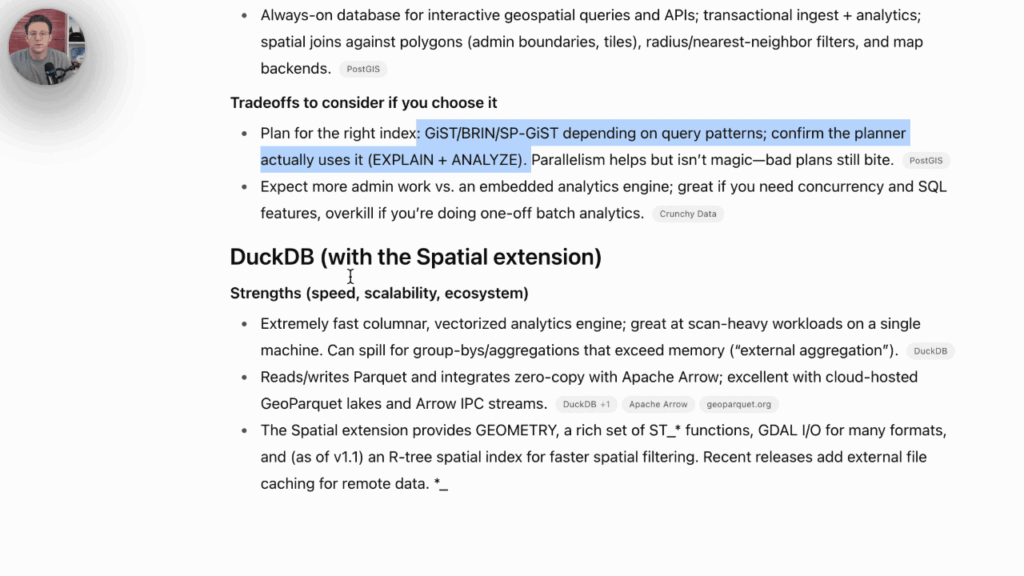
Design end-to-end flows for data prep, analysis, and delivery. Compare tools, choose the right stack, and draft system blueprints you can hand to teammates.
Organize your best prompts, workflows, and checklists into a personal AI operating manual so you can reuse patterns across projects and tools.
Build reusable AI personas tailored to GIS tasks: analysis partner, SQL coauthor, GeoPandas helper, QA reviewer. Standardize inputs and outputs so results are consistent and reliable.
AI as your daily assistant
Troubleshoot SQL, Python, and projection issues
Summarize messy requirements into a project plan
Draft documentation that others can actually follow
GIS + AI prompts that work
- Workflow steps, error fixes, and debugging for ArcGIS and QGIS
SQL patterns for spatial joins, buffers, grids, and QA checks
Python prompts for GeoPandas, raster transforms, and feature engineering
Analysis prompts for assumptions, caveats, and validation steps
Hands-on demos
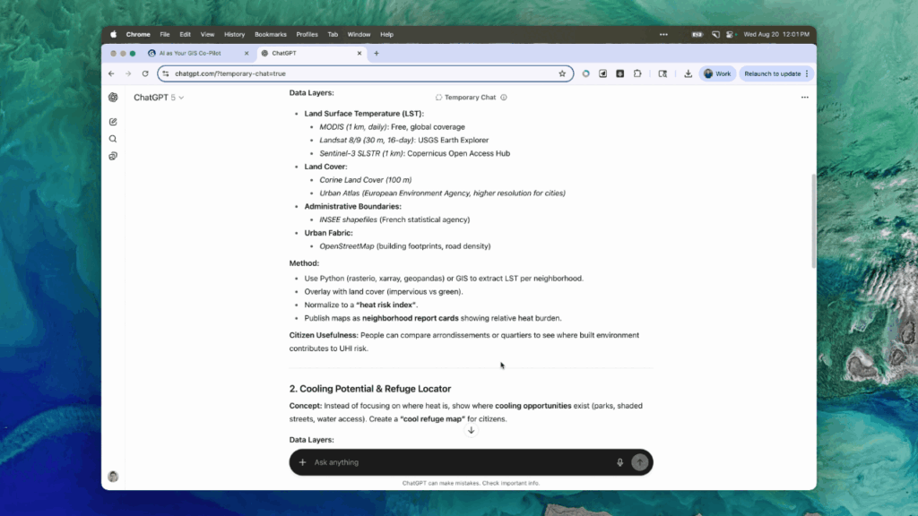
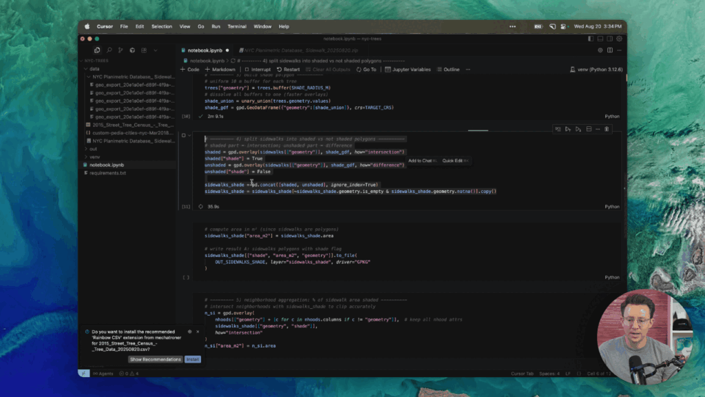
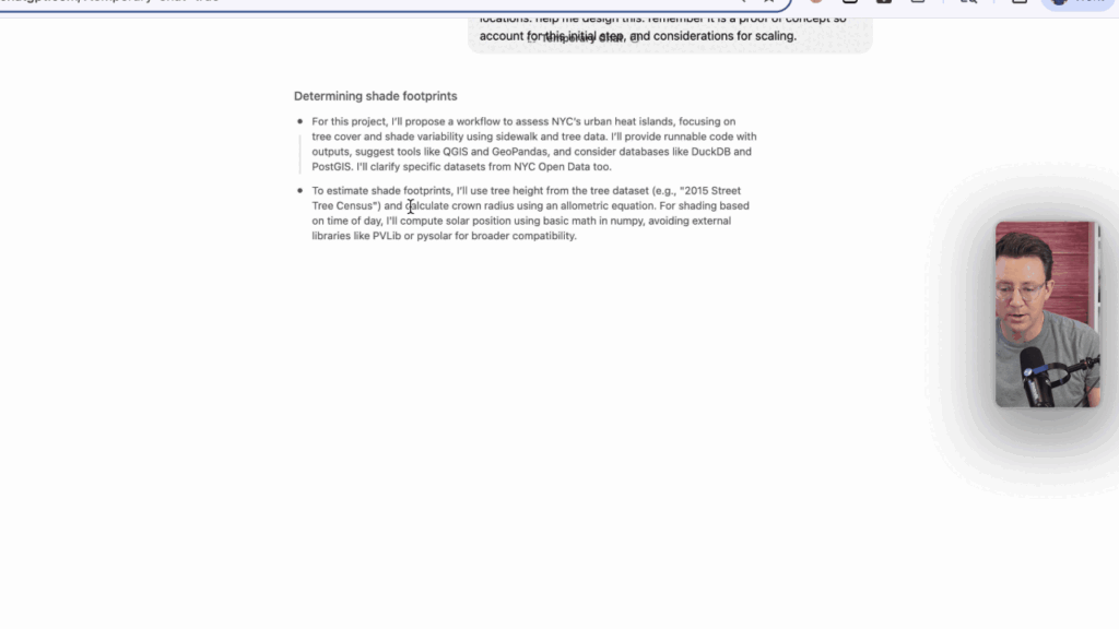
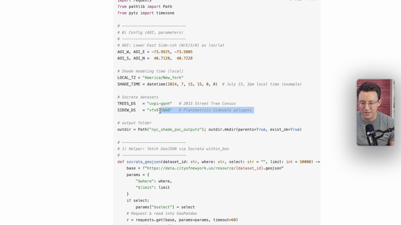
Urban heat islands, shaded sidewalks in NYC in under an hour
Data cleaning and schema standardization for repeatable pipelines
Map creation with AI-assisted styling, narrative, and export checks
Your AI workflow system
Set up reusable prompt libraries, snippets, and checklists
Create a “first draft in minutes” routine for every project
Add quality gates so speed never sacrifices rigor
The AI toolkit for impact
Turn AI into leverage with a practical toolkit—prompts, workflows, and checklists. Build, test, and ship faster on any GIS project with confidence.
~2 hours of tight, step-by-step video you can complete in a weekend
Downloadable prompt structures for Destkop, SQL, Python, and analysis
Workflow checklists and templates you can plug into real projects
Urban heat island case study you can adapt to your city
Lifetime access, future updates included

Career outcomes you can point to
Turn AI-assisted workflows into tangible wins at work. Deliver faster, communicate clearly, and show proof that you’re the GIS super user who raises the bar.
Deliver projects with less back-and-forth and clearer narrative
Present cleaner code and queries, with AI-assisted comments and tests
Build a portfolio piece that proves AI-enabled GIS is a strength
Earn trust as the teammate who unblocks, explains, and ships
Join over 3,728 learners of modern GIS
Learning modern geospatial tools can feel overwhelming, which is why I built AI Copilot with you in mind. I’ve taught 3,700+ people through my courses, from first steps in GIS to advanced cloud-native and AI. Whether you’re just starting out, leveling up your skills, or building toward a new role, you’ll find your place here.
ONE TIME - LIFETIME ACCESS
🔥 Most popular 🔥
AI Copilot for GIS
Use AI to become a GIS super hero
- 2 hours of step-by-step video lessons – short, tactical, and easy to follow in one weekend
- AI Prompt Library – copy-paste prompts for SQL, Python, spatial analysis, documentation, and career growth
- Portfolio-Ready Project Frameworks – guided exercises to turn workflows into case studies employers care about
- System Prompt Builder – create your own reusable AI copilots (career coach, GIS tutor, portfolio writer, etc.)
- Productivity Boost Pack – prompts + examples for debugging, concept explanations, and documentation
- Project Ideation Toolkit – structured prompts and templates to brainstorm and refine portfolio-worthy projects
- Workflow Architect Templates – design end-to-end GIS workflows with tool tradeoffs, datasets, and scaling notes
- Quick Wins Checklist – 5 small actions to put AI to work in your portfolio and daily GIS tasks immediately
- The AI Playbook (Notion Template) – your personal operating manual with prompts, checklists, and workflows

Hi, I’m Matt Forrest
I believe AI is the biggest shift in how GIS work gets done, not someday, right now. The people who learn to direct a copilot well will move faster, communicate clearer, and become the super users their teams rely on.
I have taught 3,700+ learners across my courses and I see the same pattern. Most GIS pros are strong in spatial thinking, they lose time to boilerplate code, documentation, and endless troubleshooting. AI turns those pain points into leverage.
My background spans open source projects, geospatial product launches, and work with top data teams. What changed my own practice was building a repeatable AI workflow, prompts that fit spatial tasks, checklists that keep quality high, and habits that make speed reliable.
This course condenses those patterns into something you can use in a weekend. Real GIS demos, copy ready prompt packs, and a simple operating system for AI in your daily work. We also cover validation and guardrails so results are trusted, not just fast.
My goal is straightforward. Help you work with more clarity and impact, prove AI enabled GIS in your portfolio, and step into the future of our field with confidence.
You've earned
your seat.
You’ve built the skills, now add leverage.
Step into the course that turns AI into your GIS copilot, and become the super user your team counts on.
Cut the noise. Keep the edge.
We've got answers
Common questions you might be having
No. The course shows you how to use AI to bridge gaps and accelerate common tasks. If you can describe what you want in plain language, the copilot can help you produce SQL, Python, and clear analysis narratives.
Yes. The prompts and workflows are tool-agnostic, with examples that connect to Esri and QGIS realities, including common export, CRS, and layout steps
We cover guardrails and validation, including QA prompts, test queries, and sanity checks so AI suggestions are verified, not blindly trusted.
Most learners build their first AI-assisted workflow the same day. The real gains come from turning it into a habit with the included checklists and prompt packs
You get course updates for life. Periodic live Q&A sessions are offered, and replays are available if you cannot attend.
We offer a 14-day money-back guarantee for AI Copilot for GIS. If the course is not a fit, request a refund within 14 days of purchase.