TOP OF THE STACK What we need to do with COGs COGs (Cloud-Optimized GeoTIFFs) are one of the most promising tools we have for making raster data truly cloud-native. They let you stream just the pieces you need, work remotely, and plug into modern geospatial systems without downloading giant files. But after working closely with … Continue reading Scaling GIS Workflows with COGs, Airflow, and Apache Iceberg
Tapping into the power of spatial SQL aggregations
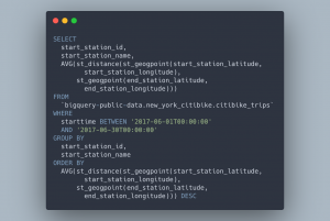
Use aggregations in SQL to group your data and perform large scale spatial joins Picking up where we left off from our last tutorial, we will jump right into the next set of topics: Using the WHERE clause to do more advanced filtering of your data Aggregations by grouping your data, filtering aggregated data using … Continue reading Tapping into the power of spatial SQL aggregations
Related posts
From Desktop GIS to Cloud: A Beginner’s Roadmap to Modern GIS Tool
Modern GIS is changing fast. If you’ve been working with QGIS, ArcGIS, or any other desktop GIS tool, you’ve probably hit some limitations—datasets getting too big, processing times slowing down, and collaboration becoming a challenge. The good news? The cloud offers a way forward. But how do you make that transition? How do you go … Continue reading From Desktop GIS to Cloud: A Beginner’s Roadmap to Modern GIS Tool
The Top 11 Open GeoParquet Datasets: Making big geospatial data easy
In the dynamic field of geospatial technology, the evolution of data formats plays a pivotal role in shaping how we interact with and interpret spatial information. The advent of GeoParquet has marked a significant milestone, offering a more efficient and accessible way to handle large spatial datasets. This blog post delves into a comprehensive exploration … Continue reading The Top 11 Open GeoParquet Datasets: Making big geospatial data easy